Enter to win custom GasGas Dirt Bike + Moab Trip! Click Here

Lost Trails Guidebook #26 | San Rafael Swell | Segers Hole Overlook

Sep 13, 2022

Why you should submit here, even if you already have elsewhere!

We keep them honest. If everyone only comments through the government/agency site, we have to take their word on how many comments were received. By submitting through BRC, we create an independent record of our community’s response that can’t be buried or under-reported.

We protect your voice. If this fight ends up in court, having our own record of submitted comments means we don’t have to wait a year or more for a government agency to turn over documents. We can move quickly with proof that thousands of you spoke up.
We keep you in the loop. When you comment through our site, we can send you updates on what comes next. If you only use the government/agency site, you’re depending on them to tell you what happens next — and they won’t.

Double coverage matters. Even if you’ve already commented through the government/agency site, submitting through ours makes your voice count twice — once in their system, and once in ours. That way they know the OHV community is watching and tracking every move.

For years, BRC has been trusted to run action alerts like this. Thousands of members and supporters have used this system effectively to defend access to public lands. This isn’t about collecting your info — it’s about building the strongest, most transparent record possible to hold agencies accountable.

Why you should submit here, even if you already have elsewhere!

We keep them honest. If everyone only comments through the government/agency site, we have to take their word on how many comments were received. By submitting through BRC, we create an independent record of our community’s response that can’t be buried or under-reported.

We protect your voice. If this fight ends up in court, having our own record of submitted comments means we don’t have to wait a year or more for a government agency to turn over documents. We can move quickly with proof that thousands of you spoke up.

We keep you in the loop. When you comment through our site, we can send you updates on what comes next. If you only use the government/agency site, you’re depending on them to tell you what happens next — and they won’t.

Double coverage matters. Even if you’ve already commented through the government/agency site, submitting through ours makes your voice count twice — once in their system, and once in ours. That way they know the OHV community is watching and tracking every move.

For years, BRC has been trusted to run action alerts like this. Thousands of members and supporters have used this system effectively to defend access to public lands. This isn’t about collecting your info — it’s about building the strongest, most transparent record possible to hold agencies accountable.

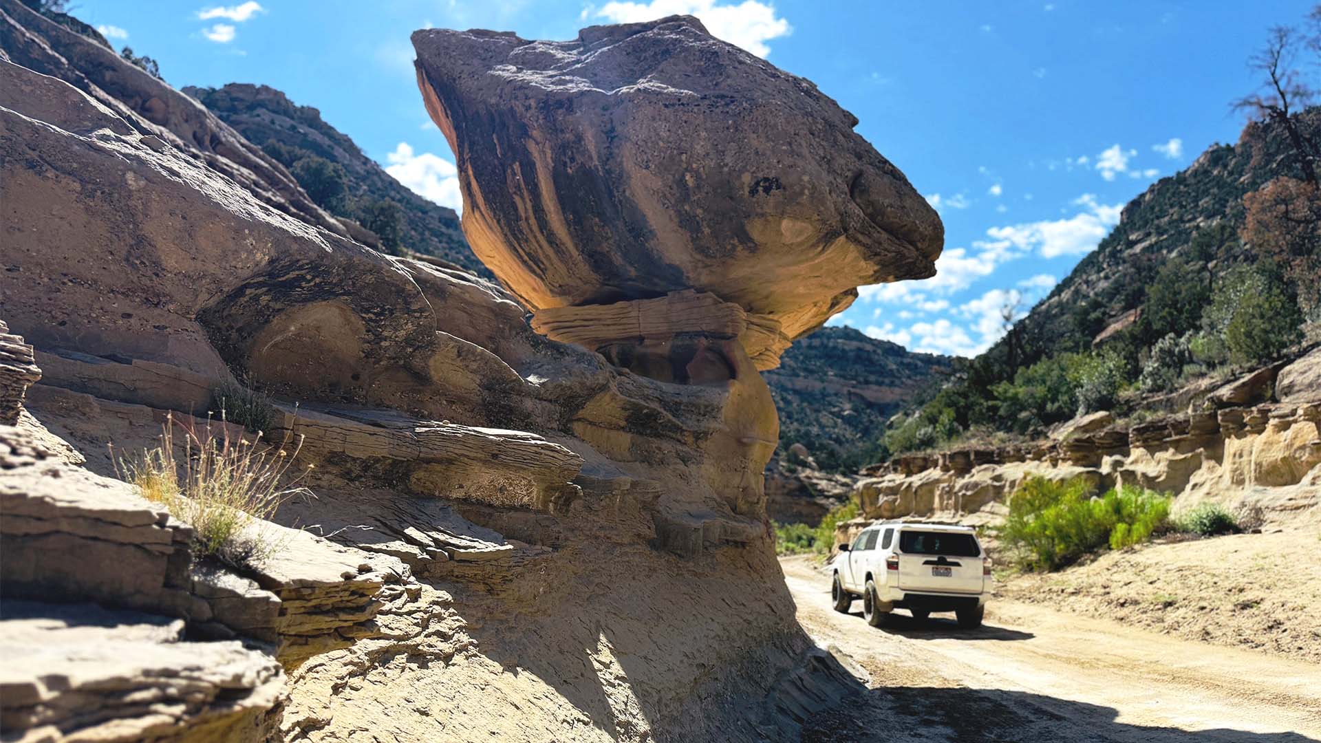
Overview: If you choose to be one of the few who choose to explore the remote southwest quadrant of the San Rafael Swell, the Segers Hole Overlook should be one of your top destinations. This overlook provides one of the best vantage points of the Muddy Creek Drainage that is home to the Hidden Splendor Mine. You will also have spectacular views of the Henry Mountains to the South. Before you head up the road to the overlook, there is a great dispersed campsite at the base of the Cedar Mountain formation. In the day we spent exploring this area, we didn’t see any other people. We shared the view with a rattlesnake.

YouTube video

Getting There: Segers Hole Overlook is further down Segers Hole Road from the Slaughter Slopes area. You will exit north from exit 99 off of I-70. You will then travel south-southeast along Willow Springs Road. This is a well maintained road that is passable by most vehicles in good conditions. Once you reach the junction with Segers Hole Road (GPS Coordinates 38.68875, -111.17503), you turn east to Follow Segers Hole Road. The road to Segers Hole leaves the main road at GPS Coordinates 38.63813, -111.11221. The great dispersed campsite is located at 38.63352, -111.11588.

View Full BLM Scoping Map for the San Rafael Swell here: https://www.arcgis.com/apps/webappviewer/index.html?id=7ab9ab7390ae4a3b8131990680a8776f&extent=-12394149.4564%2C4653898.2205%2C-12265811.6859%2C4720857.0573%2C102100

Route Conditions: Once you leave the main road, we recommend using a very well equipped, high clearance 4WD or AWD vehicle for access to both routes. As always, follow LEAVE NO TRACE practices. Irresponsible recreation leads to ecological damage, road closures, and loss of access to important resources. It is important that motorized users stay on the trail and camp within a 30′ buffer zone on either side of the road.

This route report is part of a larger guidebook BRC is completing to educate users about high-value motorized trails that are at risk of closure if we don’t use them. This guidebook will be called the Lost Trails Guidebook, and has been funded by a generous grant from the Yamaha Outdoor Access Initiative with Jorgensen Powersports as a sponsoring dealer.

Appreciate What We Do?

It takes a team of people to investigate, review, advocate and litigate in order to protect your rights to public lands. Please consider donating today so we can defend your ground.

Latest Articles
12 Days of Legal Updates: Our Lawsuit to Save the San Rafael Swell

12 Days of Legal Updates: Our Lawsuit to Save the San Rafael Swell

On December 31, 2024, just as the sun was setting on the final hours of the Biden administration, the BLM released a new Travel Management Plan for the San Rafael Swell. For generations, the Swell had been a place where families, explorers, and motorized...

Categories