The United State Forest Service is seeking public input on proposed changes to the current Tongass National Forest land management plan. In 2016 the USFS amended the plan, and is now asking the public for feedback through March 20, 2026, on how the current plan needs to change in order to better meet the needs of the public. The Tongass National Forest covers almost 17 million acres of land, includes Wilderness areas and two national monuments. The agency will be using this feedback to draft alternatives in the environmental impact statement for future management. It is important to let the Forest Service know that access, multiple use, recreation and smart management of our federal lands is crucial to not just Alaskans but the nation. Not only does this forest provide millions of visitors recreational opportunities but it provides locals the economic opportunities to sustain their communities.
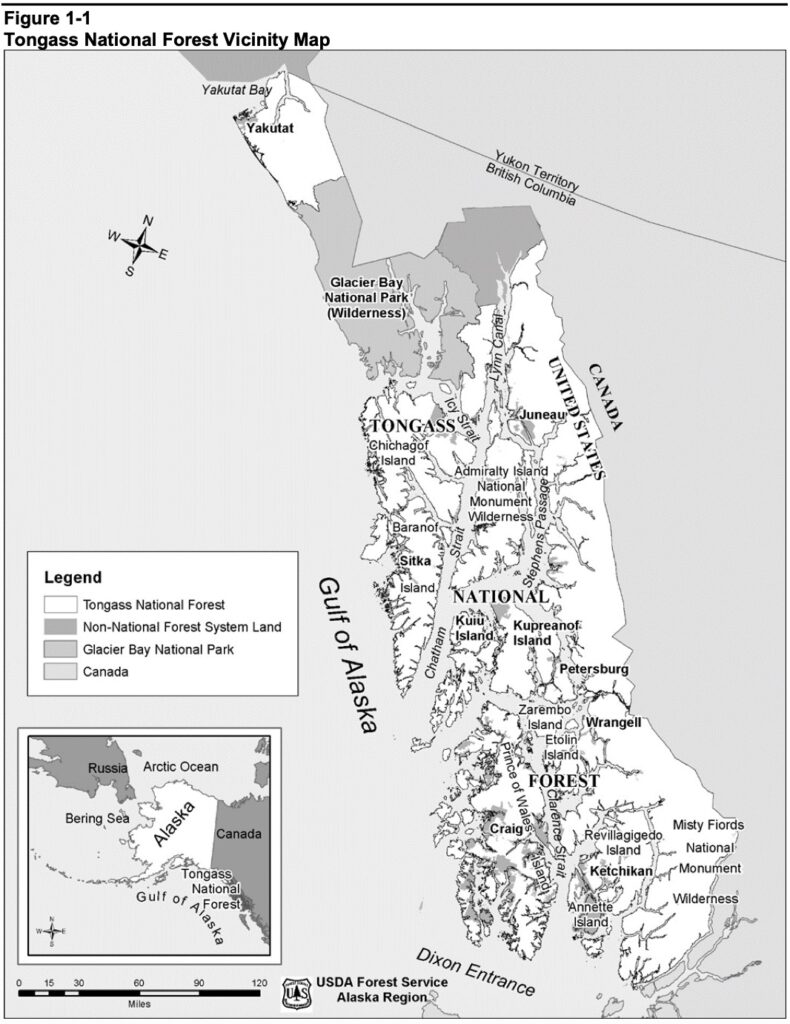
According to the USFS the current plan is insufficient in providing structure for the growing recreational needs:
"The current Tongass Land and Resource Management Plan contain direction for recreation and tourism, but does not reflect recent growth and projected changes, particularly the increase in cruise ship tourism. Outdoor recreation and tourism are the biggest private-sector economic drivers in the region. The revised plan needs to consider how to balance recreation and tourism with other uses, ensuring sustainability of the natural environment and protecting the character of the Tongass."
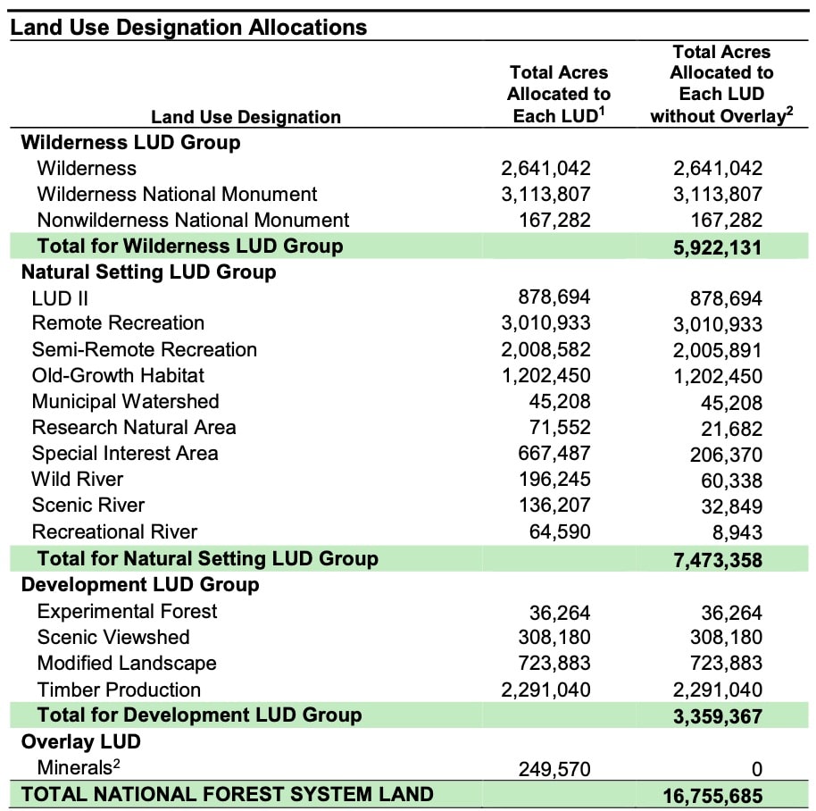
Concernes within the current plan are the Land Use Designations in the table below. National monuments should not be managed as Wilderness expecially nonwilderness national monuments. These areas assume automatic closure of roads which is not consistent with national monuments.
The current plan also has direction to " Decommission roads that are no longer needed to meet forest resource objectives." At BRC we know that roads provide different purposes for different users.
Highly Protected LUDs:
Wilderness
Purpose: Highest protection; preserve wild character
Roads/Access: No roads allowed; motorized access prohibited
Recreation: Non-motorized only (hiking, paddling)
Wilderness National Monument
Purpose: Wilderness within national monument boundaries
Roads/Access: No new roads; motorized uses restricted
Recreation: Primitive, non-motorized experiences
Nonwilderness National Monument
Purpose: National monument lands outside designated wilderness
Roads/Access: Limited development; roads generally not built
Recreation: Mostly non-motorized; managed for scenic and natural character
Natural and Sensitive Recreation / Habitat LUDs:
Remote Recreation
Purpose: Maintain remote, scenic recreation settings
Roads/Access: Roads generally limited or absent
Recreation: Non-motorized or low-impact access emphasized
Semi-Remote Recreation
Purpose: Provide less-remote experiences with some access
Roads/Access: Limited roads and trails
Recreation: Motorized access allowed only on designated routes
LUD II
Purpose: Preserve largely natural conditions
Roads/Access: Roads restricted
Recreation: Low-impact recreation; motorized use limited by travel management
Old-Growth Habitat
Purpose: Protect old-growth forest values
Roads/Access: Roads may be allowed if consistent with habitat objectives
Recreation: Allowed; motorized use limited to designated routes
Municipal Watershed
Purpose: Protect drinking water supplies
Roads/Access: Restricted to protect water quality
Recreation: Allowed where compatible with watershed protection
Research Natural Area
Purpose: Research and monitoring
Roads/Access: Restricted motorized access
Recreation: Primarily non-motorized
Special Interest Area
Purpose: Protect unique ecological or cultural features
Roads/Access: Controlled case-by-case
Recreation: Managed to protect special values
Wild River
Purpose: Protect free-flowing river character
Roads/Access: Road construction limited near waterways
Recreation: Primitive river recreation
Scenic River
Purpose: Protect scenic river values
Roads/Access: Limited road development
Recreation: Scenic-oriented recreation
Recreational River
Purpose: Provide recreation along river corridors
Roads/Access: Some road access allowed
Recreation: More developed river recreation opportunities
Developed / Multiple-Use LUDs:
Experimental Forest
Purpose: Research and demonstration forestry
Roads/Access: Roads allowed as needed
Recreation: Varies with research activities
Scenic Viewshed
Purpose: Preserve scenic quality along travel corridors
Roads/Access: Roads may be allowed but must protect scenery
Recreation: Supports scenic driving and recreation access
Modified Landscape
Purpose: Managed for multiple uses
Roads/Access: Roads allowed and maintained
Recreation: Wider range of motorized recreation
Timber Production
Purpose: Resource extraction focus
Roads/Access: Roads permitted and maintained for timber and access
Recreation: Allowed; motorized use on designated routes
Road construction, maintenance, permits and overall access and use is guided by LUD direction. Some designations prohibit motorized use, new roads (Wilderness), restrict group size (12 people of less) while others allow construction, maintenance, additional recreation opportunities and motorized use when consistent with plan standards.
Motorized use is governed through Travel Management Plans and Motor Vehicle Use Maps (MVUMs). LUDs influence where routes may exist, but site-specific decisions determine whether roads are maintained, converted to trails, or decommissioned.
Areas prioritized for conservation and remote recreation generally restrict motorized access and emphasize non-motorized, limited-access recreation, decommissioning or closure of previous routes.
Developed and multi-use zones typically support maintained road systems, timber access, and broader recreation opportunities.
It's important for the public to submit feedback on what is and isn't working in the current plan. This plan oversees millions of acres of our public lands and we want to ensure the management plan provides a framework that supports multiple use and motorized access. As recreation needs grow, management needs to sustain and support this. Submit your feedback using the form below.